Rot or not? Uncovering the spatial patterns and drivers of Norway spruce root rot with harvester data
Abstract
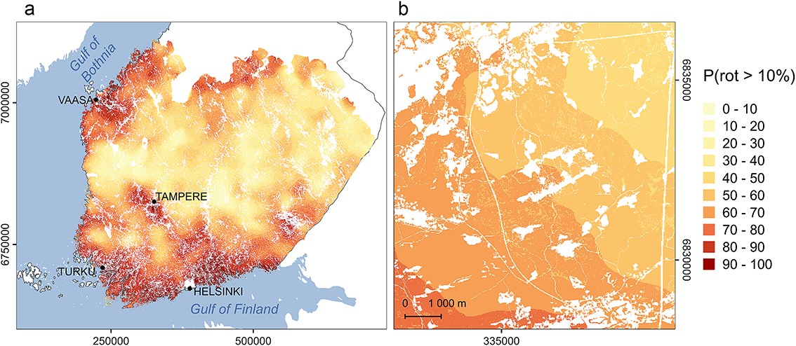
Root rot is a major problem for forestry, leading to reduced timber quality, growth losses, and increased disturbance risks. Harvester data provide a promising source of information for producing information about root rot. Here, we used harvester data (i) to map the risk of spruce root rot in southern and central Finland and (ii) to understand the drivers of the spatial root rot patterns. First, we built a model predicting the percentage of stems affected by root rot on the stand level. We used harvester data from 10,402 clear-cut forest stands, where the presence of rot was identified for each cut tree using an algorithm based on bucking patterns (i.e. how stems are cut into different log assortments) recorded by the harvester. The model consisted of two parts: a fixed component describing the effects of different drivers of root rot and a spatial random component describing the spatial patterns not explained by the fixed part of the model. The fixed part included forest and site attributes, landscape characteristics, and proxies of forest-use legacies. The model was then used to map root rot risk, by predicting the probability of root rot occurrence using spatial data sets of the variables in the fixed part of the model, and the known rot status of locations in the data set for the random part of the model. Finally, the map was tested with independent validation data, verifying its ability to identify the high-risk areas. Proxies of forest-use legacies, tree size, and site fertility were found to drive the percentage of rot-affected stems. As past forest use is correlated with climatic conditions, these variables may also include climatic effects. The results quantify the root rot risk in Finland in higher detail than before and demonstrate the potential of harvester data in producing information about root rot.